
ReSaMMe ("Search for submarine sand in the Mediterranean Sea")
 The ReSaMMe Project is set-up by six European partners (Italian, French, Spanish and Greek) who exploit the technical tools available for analysis of the characteristics and potential use of natural sand resources on the continental shelf within their regions; these sand resources could then be used to slow down erosion along the Mediterranean coasts. The Project aims to evaluate the potential availability of sand and gravels in the submarine deposits of participating countries. This includes new and existing sources whose main characteristics are to be analysed in order to verify their suitability for beach nourishment activities for the various coastal areas. The experience acquired during the Project will contribute to the creation of a methodological protocol which can be used for this type of research and analysis. Coastlines of involved countries will benefit directly from the Project. Thanks to the sustainability of results and the opportunity to transfer initiatives to other European coastal zones with similar problems, the Project will have a positive impact on the future, and will create the foundations for further research and development.
Beach erosion is common in many coastal areas in North Greece. Nevertheless, not much has been done so far by the state and local authorities to address this phenomenon. The ReSaMMe Project will provide the Regional Authority of East Macedonia - Thrace with the necessary data to start developing alternatives on addressing beach erosion. Such study has not been undertaken in North Greece, therefore, all results will be new and innovative. The application in North Greece will be a good test of methods developed in other countries.
Partners of our Laboratory in the ReSaMMe Project are:
- Italy: Ingegneria Ambientale struttura tematica di ARPA Emilia-Romagna (Project Coordinator)
- Italy: Università degli Studi di Roma "La Sapienza" - DST
- Italy: Università degli Studi di Genova - Dipteris
- France: Laboratoire de Biophysique et Dynamique des Systèmes Intégrés BDSI, Université de Perpignan
- Spain: Departamento de Geología Marina y Oceanografia Física Instituto de Ciencias del MarCentro Mediterráneo de Investigaciones Marinas y Ambientales CSIC
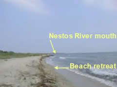 The methodology will be applied in an area in Northern Greece. The proposed area is that of Nestos River delta. What makes this area interesting is that several dams have been constructed along this river, reducing its sediment supply to the coastal area, which in turn results to beach erosion. There are also alternative sites where the mechanisms of beach erosion are different: beach erosion at these sites should be probably attributed to construction of small ports or other marine structures, which also limit the supply of sediments to the coastal area. Our involvement will present the Greek perspective on the subject of beach erosion. The Project will be significant for Greece to get involved in studies on beach erosion.
The Laboratory contribution is distributed to three Phases as follows:
In Phase A (May 2006-July 2006), we will conduct a literature search and review of methodologies used in surveying sand deposits in the continental shelf. Furthermore, in this Phase we will acquire any necessary equipment which will be used in the following two Phases. We will also use existing maps and data in identifying sand deposits and geological features in our test area.
During Phase B (August 2006-February 2007), maps will be prepared in a GIS system using existing data. The most appropriate sites for detailed surveys will be selected, and the field surveys will be designed and organized.
In Phase C(March 2007-April 2008), we will perform field surveys using side scan sonar. We will map any sand deposits and will collect sand deposit samples for quality analyses and definition of their characteristics.
During all Phases, there will be continuous communication with partners and exchange of information.